
How it works
From camera footage to a reviewed, reportable route.
RouteLens follows the way survey teams already work: record, review, record findings, check scope, deliver. Every step keeps the link back to the source moment.
The workflow
Six steps from recording to handover.
Step 1
Import footage or a GPX track
Drop files or a whole recording folder. Chapters join after a continuity check. Only the needed bytes are read: a 4 GB file needs about 5 MB.
Step 2
GPS extraction and quality checks
Fix type, DOP, gaps and impossible jumps are checked. Rejected points keep their reason, and unknown values stay unknown.
Step 3
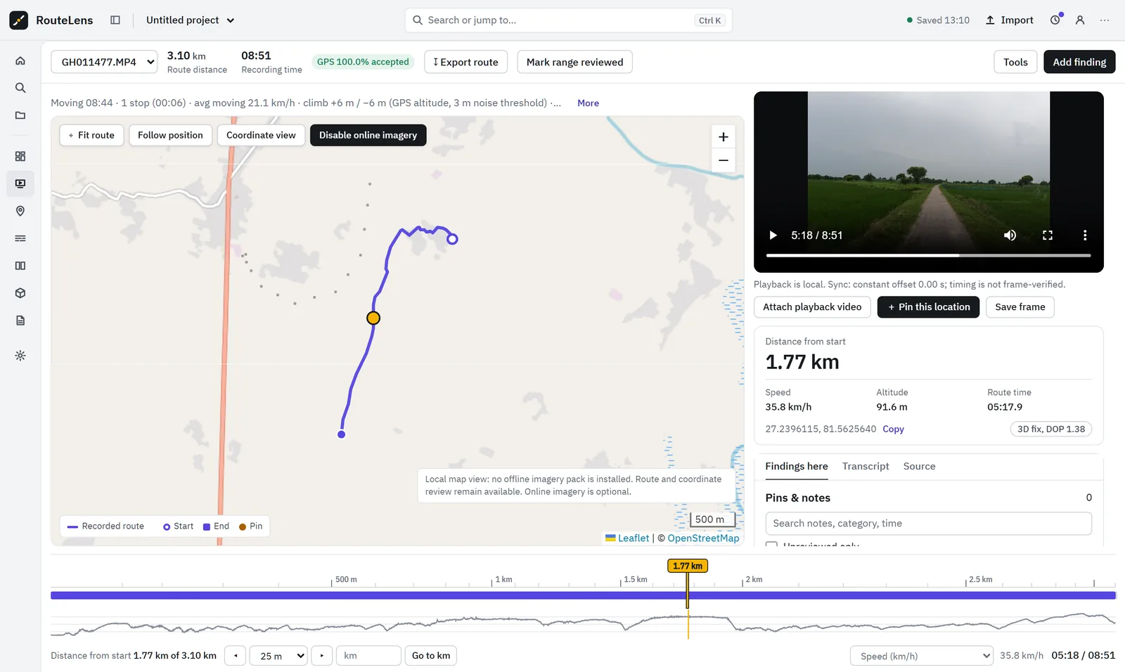
Map, video and timeline linked
Click the map, scrub the timeline or the speed chart, and the video follows. Go to any kilometre.
Step 4
Review and record findings
Mark reviewed ranges, add findings from frames, assign owners, submit and verify repairs.
Step 5
Coverage, compare, assets and search
Check planned scope, compare repeat visits, link assets and search spoken notes or signboards.
Step 6
Reports, packages and exports
Issue client reports, send offline review packages and export KML, GPX, CSV, GeoJSON and ZIP backups.
Supported inputs
Cameras and files.
We list exactly what is verified with real footage and what is built but still waiting for a real file. New camera files can be checked with the RouteLens validation tool.
| Input | Status | Notes |
|---|---|---|
| GoPro MP4/MOV with GPS5 (for example GoPro MAX) | Verified | Real 4.01 GB file, 9,316 GPS points, matched against an independent extraction |
| GoPro GPS9 (newer models) | Built | Decoder tested on a synthetic file; real file needed |
| Insta360 .insv (X3 and similar) | Built | GPS needs a connected phone or GPS remote; a real GPS-containing file needs testing |
| GPX track | Supported | Segments preserved; attach a playback MP4 separately |
| Video without GPS (MP4, MOV, WebM, M4V) | Supported | Library, playback and review; no route is drawn |
| Asset register (CSV / GeoJSON) | Supported | Import with field mapping |
| Planned scope / reference route | Supported | For coverage and chainage |
| GoPro MAX .360 originals | Not yet | Export a stitched MP4 first |
Quick start
Running in five minutes.
- Start the local launcher (Start Dashboard.bat, or python dashboard/preview.py).
- Open http://localhost:8765 in Chrome or Edge.
- Click Import footage, or drop files or a whole recording folder.
- The route appears with start and end markers.
- Click the map, scrub the timeline or the speed chart: the video follows.
Python 3 is enough. FFmpeg is optional. Without Python, the launcher falls back to a PowerShell server built into Windows.

Next step
See RouteLens on your own footage.
Book a 30-minute walkthrough. Bring a recording and a sample report, and we will show you the map, video, findings and coverage working together.